Navigation Charts               Locking               Navigation Notices

McClellan-Kerr Arkansas River Navigation System

The 445-mile navigation channel begins at the confluence of the White and Mississippi Rivers and proceeds one-half mile upstream on the White River to the Montgomery Point Lock and Dam.  From there the channel proceeds nine miles upstream on the White River to the man made Arkansas Post Canal, and then nine miles through the canal to the Arkansas River.  The McClellan-Kerr Arkansas River Navigation System crosses the state of Arkansas into Oklahoma traversing the state until it reaches the confluence of the Arkansas and Verdigris River where the navigation channel follows the Verdigris River terminating fifty-one miles upstream at the Port of Catoosa, near Tulsa, Oklahoma.

PDF version of Map

* Minimum depth of nine feet
* Width of 300 feet on the White River
* Width of 300 feet on the Arkansas Post Canal
* Width of 250 feet on the Arkansas River
* Width of 150 feet on the Verdigris River
* 18 Locks, each 110 feet wide and 600 feet long

Commercial Activity

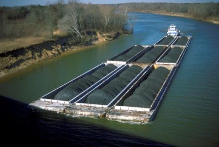
Commercial activity on the McClellan-Kerr Arkansas River Navigation Systems waterway includes up bound barges of bauxite, grain, chemicals, fertilizer, steel, pipe, asphalt, soda ash, petroleum products, clay, sand, gravel and miscellaneous commodities.  Down bound barges ship soybeans, wheat, lumber, steel, coal, gypsum, scrap iron, rock, refined petroleum products and manufactured equipment.  Barge transportation is significantly more efficient than rail or truck per ton of freight moved per mile.  Benefits also include reduced noise, air pollution, and roadway congestion.

2023 MKARNS Waterway Action Plan

Flow Management

The upstream lakes and dams in Oklahoma play a critical roll in the operation of the navigation system, since there is no floodwater storage allocated in the Lock and Dam Reservoirs.  Each reservoir operates for their individual authorized purposes; however, in the case of flood risk management each reservoir has limitaions according to downstream conditions.  Linked by their discharge to the same river system, the Arkansas main stem, the reservoirs operate not only for local conditions, but also as a part of a larger system.  Integrated with other projects, these lakes help to reduce high flows and augment low flows on the Arkansas and the Mississippi Rivers.