 Authorization: Flood Control Act approved June 28, 1938, Project Document HD 541, 75th Congress, 3d Session (flood control and power); Public Law 868, 76th Congress, 3d Session, approved October 17, 1940, (improving navigation, regulating flow of Red River, controlling floods, and other beneficial uses); Public Law 454, 78th Congress, 2d Session, approved September 30, 1944, (impoundment designated as Lake Texoma); Public Law 273, 83rd Congress, 1st Session, approved August 14, 1953, (Denison water supply storage); Public Law 164, 84th Congress, 1st Session, approved July 15, 1955, (construction of Willis Site Bridge); Public Law 146, 85th Congress, 1st Session, approved August 14, 1957, Project Document HD 541, 75th Congress, 3d Session, (Sherman water supply); Public Law 282, 91st Congress, 1st Session, approved July 19, 1970, (water supply dam on Big Mineral Arm); Public Law 662, 99th Congress, 2d Session, approved November 17, 1986, (added recreation as a project purpose and authorized reallocation of additional storage for water supply).
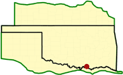
Location: On the Red River at river mile 725.9, 5 miles northwest of Denison in Grayson County, Texas.
Status: Complete.
Purpose: Flood control, water supply, hydroelectric power, regulation of Red River flows, improvement of navigation, and recreation.
History of Construction: Construction began in August 1939 and was completed in February 1944. The project was first available to operate for full flood control without any restrictions in January 1944. The first hydroelectric turbine was placed on line in March 1945 and the second in September 1949. The additional power units were deauthorized April 16, 2002. Generator rehabilitation occurred from 2004 to 2006 resulting in an uprate to 50,000 kW per unit. As of April 2020, there is an ongoing turbine rehabilitation which started in 2014. Unit 1 rehab was completed and the unit was commissioned in 2020. Construction of a highway bridge across Lake Texoma at the Willis Ferry site started April 24, 1958, and was completed October 30, 1960. The 5,426-foot-long bridge replaces a former crossing south of Woodville, Oklahoma, on Oklahoma State Highway 99 and Texas State Highway 91. The roadway surface is about 37 feet above the top of the power pool.
Type of Structure: The structure is a rolled, impervious and semi-impervious earth-filled dam about 3,000 feet long with a maximum height of 197 feet above the streambed. Oklahoma State Highway 100 extends across the top of the dam. An earth-filled dike about 1,350 feet long is located between the right end of the dam and the spillway. It has a maximum height of 45 feet, and a design crest height of 676.7 feet.
Spillway & Outlet Works: The uncontrolled spillway is a concrete-gravity, chute-type structure, 2,000 feet long, located in a saddle on the right bank. Spillway capacity at maximum pool (elevation 666.4) is 1,050,000 cubic feet per second (cfs). The outlet works consist of three 20-foot-diameter, concrete conduits through the embankment equipped with six 9- by 19-foot vertical lift gates and one emergency gate. Capacity of the outlet works is 67,500 cfs at the top of the flood control pool and 60,120 cfs at the top of the power pool. Limiting channel capacity below Denison Dam is about 45,,000 cfs.
Hydrologic Data: The estimated peak discharge for the May through June 1908 flood (pre-construction) was 470,000 cfs. The volume was 8,517,000 acre-feet, which is equivalent to 4.73 inches of runoff. The peak inflow for the May 1990 flood was 300,000 cfs with a volume of 5,087,000 acre-feet and a record release of 144,900 cfs. The peak inflow for the May through June 1987 flood was 315,000 cfs with a volume of 2,879,000 acre-feet. The total volume of inflow for the 1957 flood was 8,364,000 acre-feet. The May-June 2015 flood produced a pool of 645.72 feet with a volume of 8,869,354 acre-feet. Gate outages prevented full releases, as a result the peak discharge during the 2015 flood was 141,060 cfs. Peak inflow for this flood was 290,700 cfs.
Hydropower: The intake structure is located immediately upstream from the dam near the Texas abutment. Eight 20-ft diameter conduits approximately 800-ft long pass beneath the dam to the powerhouse and outlet channel. Six are flood-control conduits and two are power penstocks. Each power penstock is connected to a 95-ft high, 55.5-ft diameter surge tank. Flow is controlled by 9- by 19-ft tractor-type gates. The release capacity of the powerhouse is approximately 10,100 cfs. A 50KW unit and a 40KW unit are currently waiting to be upgraded. There are no provisions for any additional units. Power unit 3 was de-authorized April 16, 2002.